Digitalization in the Business, Industry and Mining Sectors
DESCRIPTION
AKURA MeeTC provides the service of digitalization in the industry and mining sectors
When
Jan 2020 - ....
Who
The services are conducted and supplied conducted with the support of academicians in various fields from leading universities.
AKURA provides service of digitalization of industry and mining sectors and handling complex engineering problems by employing multidisciplinary teams. AKURA’s activities are as follows;
-providing service and consultancy comprising research, system design and development, to mining sector at multiple verticals.
- providing service of mine exploration, recycling and reuse of mining waste,
- introducing innovative technology and scientific knowledge for digitalization of industry and mining sectors,
- providing engineering services including mine surveying, environmental risk and impact determination, subsidence, displacements and surface deformation due to mining operations among others.
DESCRIPTION: project 1
Estimating the Potential Resource of Black Amber and Mapping at a Test Field
When
Jan 2015-Jan 2016
Who
Client/for Whom: funded by Regional Development Agency (KUDAKA) and Atatürk University to support the circular economy in the semi-valuable stone sector to support local industry.
PROJ 2.1: INTEGRATED MINE EXPLORATION TECHNOLOGY

Identifying the Challenge & Requirements:
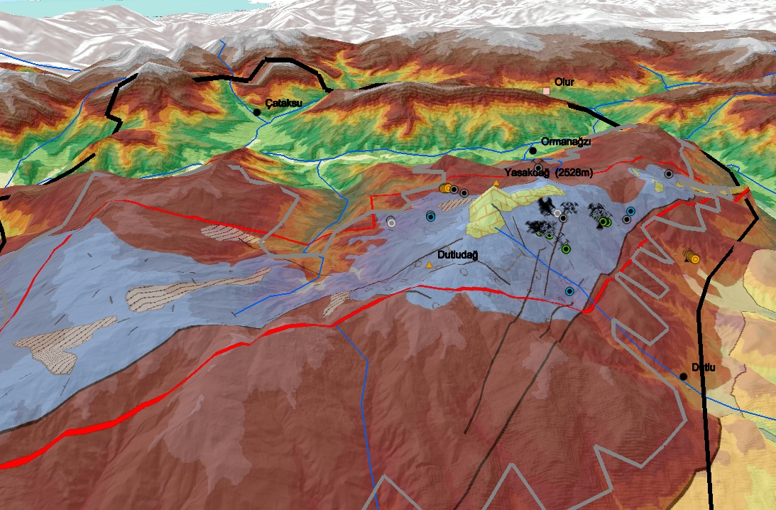
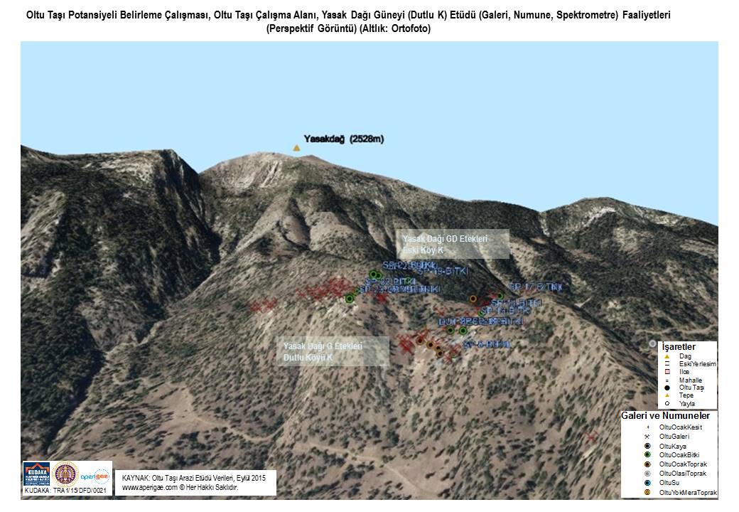
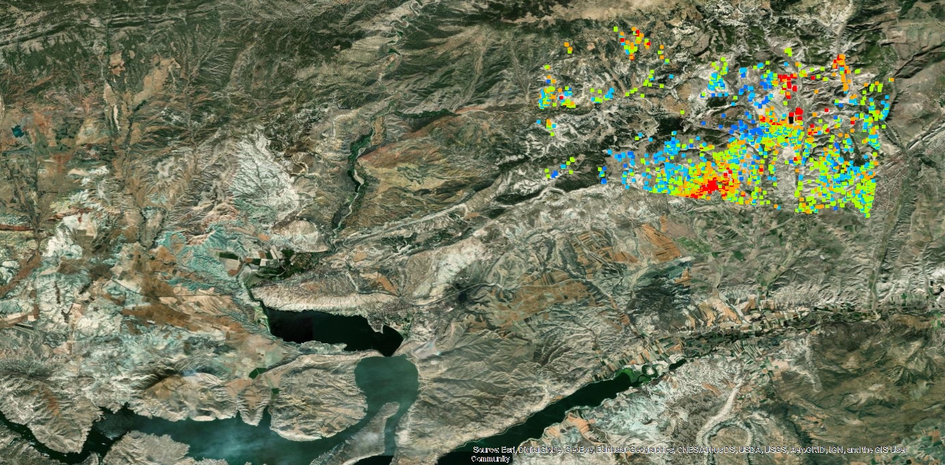
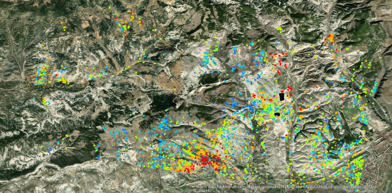
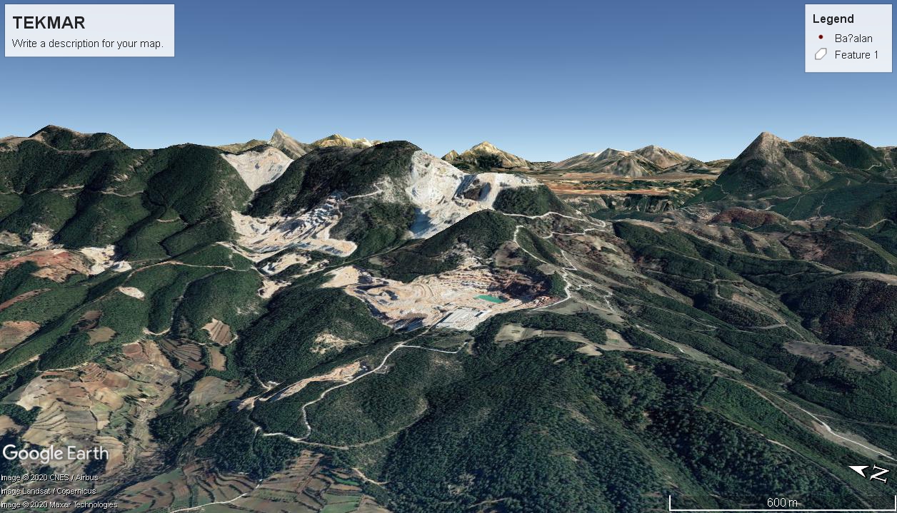
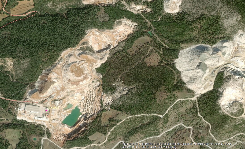
The local administrative bodies andsemi-valuable stone sector used to have some concerns on the available potential Oltu Taşı resource. This local requirement is responded by conducting a mine exploration project to use the state of the art technology.‘APERIGAE Information Technologies Consulting’ was previously founded has been in the sector since 2015 and main partner of AKURA MEETC. Currently, AKURA and APERIGAE, being as partner companies, are jointly cooperating to handle the tasks together.
The Approach, Conducted Work:
This work comprises research andprofessional works of surveying, geology, geomorphology, vegetation, forestry,mine surveying, mining, soil, environment sciences, GIS, remote sensing –andradio spectrometry-. The sister company APERIGAE gathered an interdisciplinary team of 23 researchers, academicians and professionals from. The project team supplied with all relevant geospatial data including ortho-photo, satellite imagery, topographic maps, geodatabases for soil, forestry, fielddata, thematic data generated from satellite imagery, statistical data, laboratory analysis and so on. The data and results are disseminated through a geoportal prototype comprising web services, data analytics among others. 
Output:
The Project Team created meaningful results on probable potential reserve, proposed locations for drilling after a comprehensive work in the field and at laboratories of Middle East Technical University (METU) and Ataturk University (ATAUNI).
Partners, Alliance:
The project is conducted with the support of academicians from Middle East Technical University (METU) and Ataturk University (ATAUNI), Cumhuriyet Univ. (Sivas), Professional Geologists and Radio Spectrometer Experts
DESCRIPTION: project 2
Monitoring Subsidence in Mines, Deformation Monitoring for a Hydro-dam and Landslides.
When
Jan 2017- ....
Who
Client/for Whom: this consultancy service is provided to multiple public institutes and private companies to support their decision making process
PROJ 2.2: TECHNOLOGY DRIVEN MONITORING BIG-STRUCTURES

Identifying the Challenge & Requirements:
Determining vertical/horizontal displacements in mines namely subsidence, deformation monitoring for big structures such as dams and landslides, monitoring the displacement changes in time of railway networks and urban subsidence along underground network and at shores are the challenges understand in order to manage the risks and to make decisions for structure health.  
The Approach, Conducted Work:
Deformation surveying and analysis, as one of the basic problems of engineering-geodesy and surveying, is an indispensable part of risk management and safety of mines, big structures and network infrastructure. AKURA handles these problems by employing scientific knowledge and state of the art technology such as satellite interferometric radar techniques (InSAR), terrestrial InSAR, aerial/terrestrial LiDAR, various sensors and modern geodetic surveying technologies including GNSS and robot totalstation. A requirement has been raised by aprivately-owned dam recently constructed and operated to help them understand the dynamic behavior of the dam itself and surrounding fields. These tasks are handled by establishing team consisting of geodesists, geologists (landslide and engineering) and experts of rock mechanics, hydraulics and hydrology.  
Output:
AKURA is continuing  consultancy for big structures. Partners, Alliance:
The project is conducted with the support of academicians from Middle East Technical University (METU), Hacettepe University (Ankara), Ataturk University (ATAUNI), Cumhuriyet Univ. (Sivas), Yildiz technical University, Bulent Ecevit University, and Ataturk Univ (Erzurum) and Gebze Tech. Univ., Professional Geologists and Radio Spectrometer Experts
DESCRIPTION: project 3
Mine Waste Sites and Environmental Protection by using Satellite Images
When
Jan 2017- ....
Who
Client/for Whom: funded by European Bank for Reconstruction and Development (EBRD) to support the circular economy in the natural stone sector
PROJ 2.3:  INTEGRATED WASTE SITES IDENTIFICATION BY USING SATELLITE & INFORMATION TECHNOLOGY

Identifying the Challenge& Requirements:
The trend of area use for waste storage is increasing in time. The marble quarries in the region have been extending the extraction and dumping areas in accordance with as the growth rate of natural stone sector of Turkey. Remote sensing is a technology to explore, identify and discover the earth by using digital image analysis and finally creating thematic maps to understand the spatial phenomena and change on Earth surface.
The Approach, Conducted Work:
The extend of marble waste fields, location selection and transportation costs are determined by means of Geographical Information System. The marble quarrying and waste areas are quantified by using satellite data analysis (remote sensing). Multispectral and radar satellite imagery data are used to localize the quarrying and waste sites. The change and evidence of extension of quarried topography in the last decade are clearly distinguished in the satellite imagery analysis.
Output:
The satellite data analysis has shown that the amount of marble waste is much more than the declared quantities and statistical data by the governmental bodies.
Partners, Alliance:
The project is conducted with the support of academicians from Middle East Technical University (METU) and Ataturk University (ATAUNI),
Challenges & Opportunities
In order to overcome tough challenges, share your view and collaborate !
Start Now